The Plains of Abraham: The Tale of a Toponym
The Plains of Abraham: The New World’s Laboratory
Settlement on the Plains of Abraham :
- The French Regime (1608-1759)
- Stratefic Value of the Heights of Abraham under the British Regime (1759-1860)
The Plains of Abraham, the Focus of Quebec City’s System of Defence :
The Plains of Abraham: The Tale of a Toponym
The Plains of Abraham” is the name commonly used to designate the Battlefields Park. Located on a natural promontory along the North Shore of the St. Lawrence River, the site has been the focus of the development of Quebec City since its founding by Samuel de Champlain in 1608.
Where does the name come from, one might ask. The most probable explanation traces it back to Abraham Martin (1589-1664), a friend of Samuel de Champlain’s, also known as Abraham the Scot, who came to New France around 1620. A pilot on the St. Lawrence and a high seas fisherman, he was apparently Canada’s first “Pilote du Roi.” Accompanied by his wife, Marguerite Langlois, with whom he was to have nine children, he moved to Quebec City and in 1635 received 12 acres from the Company of New France. Ten years later he received an additional 20 acres as a gift from le Sieur Adrien Du Chesne, a Navy surgeon. Divided between the Lower Town and the Quebec promontory, his property extended from the area around the Saint-Charles River to the Grande Allée, encompassing a good portion of what is today the Saint-Jean-Baptiste district. It was sold to the Ursulines a few years after his death.
Contrary to the usual practice, history has used Abraham Martin’s first name rather than his second name. The name was used quite early, with the toponym “Abraham” having first been recorded in writing back in the 18th century, at which time it was used in reference to various geographical indications. It is found in some notaries’ acts to designate the northern escarpment of the Quebec City promontory. This slope, which is gentler than the cliff facing the river to the south, was called the “côte d’Abraham.” The toponym was also used to name a road. On a map from 1734, “rue d’abraham” is shown running into the “Chemin de La grande allez.”
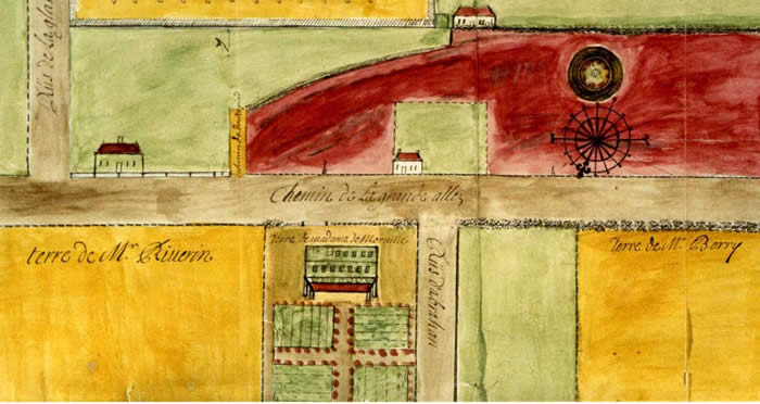
This 1734 plan has the first precisely located mention of the place name ''Abraham". ''Rue Abraham" joins Chemin de la Grande Allée, but does not continue southward to the current site of the Plains of Abraham park.
Credit: Henry Hiché, Plan appended to a notarized contract, BANQ
The toponym was probably very much a part of popular parlance, but was officialized in connection with the events of 1759–60 by the militaries, both French and British. Referring to the heights of the promontory, a strategic site in the city’s defence, le Chevalier de Lévis wrote in his journal, “On the night of the 18th to the 19th [July 1759], they [the British] had four ships positioned above the city, putting that part of it in danger. Detachments were sent to the heights of Abraham […]. “ Lévis describes a hill that he calls “la côte d’Abraham” “running roughly parallel to the St. Lawrence River and into it at the mouth of the Rivière du Cap rouge.” Not to be outdone, the British military, in the person of John Knox, a captain of the 43rd Infantry Regiment, wrote in his journal, published later as The Siege of Quebec, that after disembarking at l’Anse-aux Foulons and scaling the cliff, the troops “marched towards the town by files, till we came to the plains of Abraham.”
With time, the toponym “Abraham” came to refer to a number of different things. In the 18th century it was used to denote the northern escarpment of the Quebec City promontory, but today the côte d’Abraham refers only to a road joining Quebec’s Upper Town to the Lower Town. The territory known as the Heights or Plains of Abraham has also varied considerably. Originally it included the Quebec promontory in its entirety. Even in 1808, the toponym is written between Chemin Sainte-Foy and the Grande Allée (1808 Map, Culte p. 31). After the extension of the Faubourg Saint-Jean in 1820, the toponym shifted somewhat westward and then gradually over to the southern part of the Grande Allée in the 1840s. The territory referred to as the “Plains of Abraham” diminishes considerably in size in subsequent decades, to the point where in the early 20th century, even with the creation of the National Battlefields Commission in 1908, it included only the land between what is now the Musée national des beaux-arts du Québec and the Mérici Estate. Not until the successive phases of development of the Battlefields Park, which extended over about 50 years, did the toponym “Plains of Abraham” come to designate the entirety of the park that is today the pride of Quebec City.
Journal des campagnes du Chevaliers de Lévis en Canada, de 1756 à 1760, Montréal, C.O Beauchemin & Fils, 1889, p.184.
Journal des campagnes du Chevaliers de Lévis, p.273.
John Knox, The Siege of Québec and the Campaigns in North America, 1757-1760, Brian Connell Ed., Mississauga, Pendragon House, 1980, p. 196.
Jacques Mathieu and Gilles Ritchot, “Le cadre naturel des hauteurs d’Abraham,” in Jacques Mathieu and Eugen Kedl dir., Les plaines d’Abraham : le culte de l’idéal, Sillery, Septentrion, 1993, p. 32.
The Plains of Abraham: The New World’s Laboratory
The resources of the New World were a source of interest to Jacques Cartier as he explored the St. Lawrence in the 16th century. Part of his quest, as one might expect, centred on precious metals and stones, but he was also fascinated with the trees and plants growing on the western end of the Quebec City promontory. Some regard him as New France’s first naturalist. A century later Louis Hébert, Quebec’s first colonist, also took an interest in Canada’s flora. An apothecary by trade, he conducted experiments on his lands in an effort to learn about herbs and plants of medicinal value. His expertise in this area led Champlain to entrust to him the responsibility of acclimatizing apple trees transplanted from Normandy. It was probably Hébert who, directly or indirectly, supplied Canadian plants to Jacques Cornuti, a scientist from the Paris faculty of medicine who in 1635 published Canadensium Plantarum, Aliarumque nondum Editarum. This was Canada’s first book on plants and contains descriptions of some 80 species and varieties.
The current site of the Plains of Abraham was an ideal location for naturalism experiments. In the 17th century it was examined by learned individuals associated with the Académie royale des sciences de Paris and other European institutions. Three of these scientists in particular left their mark on the history of the Plains.
The first, surgeon, physician and botanist Michel Sarrazin lived in New France between 1685 and 1694 and served as a surgeon in the Marine. He returned to France for three years, after which, in 1697, he settled in the colony once and for all. The land held by him in the Saint-Jean fief appears to have included a portion of what is today the Battlefields Park. For more than 20years Sarrazin sent specimens of plants and bulbs to the brand new Muséum d’histoire naturelle in Paris. He is recognized as one of Canada’s premier botanists, and by the time he died in 1734 he had compiled close to 175 works, including the popular Catalogue et histoire des plantes du Canada.
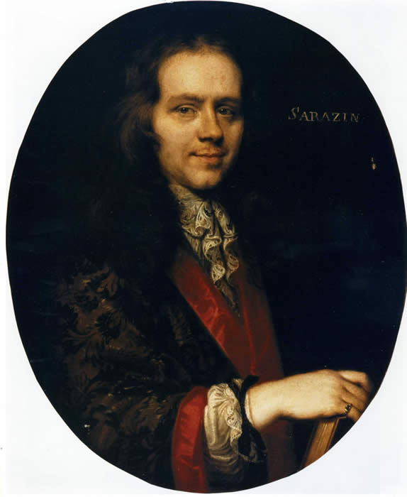
Michel Sarrazin (1659-1734) scholar, member of the Académie des sciences de Paris, surgeon, and naturalist, who collected plants on the Plains of Abraham.
Credit: Oil painting by Pierre Mignard, Musée de l’Île Sainte-Hélène.
The post of king’s physician remained vacant after Sarrazin’s death until 1742, when it was assigned to Jean-François Gaultier. As a botanist as well as a physician, Gaultier followed in his predecessor’s footsteps, having received Sarrazin’s collection of books after his death and his 200-page manuscript, Histoire des plantes du Canada, written in 1707. Like Sarrazin, Gaultier was in constant touch with Europe’s scientists and sent numerous bulbs and plants back to the mother country. At the request of Roland-Michel Barrin de la Galissonière, Governor of New France, he embarked on the preparation of a complete inventory of Canada’s plants.
An inhabitant of the Upper Town, Gaultier was doubtless quite familiar with the resources found on the Plains. For example, he used water containing iron oxide from one of its mineral springs and one of its varieties of wintergreen on his patients at the Hôtel-Dieu Hospital. He also guided the renowned Swedish botanist Pehr Kalm during his visit in 1749. Working together, the two scientists scoured the heights of Quebec City in a successful search for hitherto unknown plant specimens. Their discoveries were written in an unfinished manuscript of Kalm’s. His journal contained at least 40 new species found on what is probably the present site of the Plains. Among these, three are named in honour of his colleagues and predecessors: the first, wintergreen, he called La Gaulthiera in honour of Jean-François Gaultier; the second, Sarracenia purpurea in memory of Michel Sarrazin; and the third, Galissoniera in honour of the former governor, Roland-Michel Barrin de la Galissonière, a learned man and a natural science enthusiast.
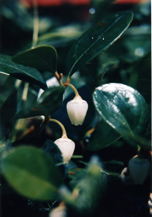
Teaberry (Gaultheria procumbens). This variety of wintergreen was named by the great French herborist Linnaeus, who dedicated it to Jean-François Gaulthier, botanist and king’s physician in the mid-eighteenth century. This plant was known for its properties as an astringent, stimulant, and antidiarrheic.
Credit: Photo Ariane Giguère.
Kalm’s and Gaultier’s interests included geology, meteorology and astronomy as well as botany. The two scientists studied the schists characteristic of the ground under the Plains and the rocky hill on which Quebec City is built. Gaultier also conducted meteorological experiments, keeping records of daily temperatures. Kalm measured the variations between true north and magnetic north and was thus able to determine the exact geographical location of Quebec City.
Without question, explorers and scientists like Jacques Cartier, Louis Hébert, Michel Sarrazin, Jean-François Gaultier and Pehr Kalm helped to explore and develop the heights of Quebec City, thereby contributing, each in his own way, to the progress of science. Long before it was named, Battlefields Park was known for the abundance and diversity of its natural resources and for its suitability as a place in which to conduct scientific experiments.
Jacques Mathieu and Alain Laberge, “À l’époque de la Nouvelle-France”, in Jacques Mathieu and Eugen Kedl dir., Les plaines d’Abraham: le culte de l’idéal, Sillery, Septentrion, 1993, p. 55.
Jacques Mathieu and Alain Laberge, «À l’époque de la Nouvelle-France », p. 60.
Jacques Mathieu and André Daviault, Le premier livre de plantes du Canada. Les enfants des bois du Canada au Jardin du roi à Paris en 1635, Sainte-Foy, Les Presses de l’Université Laval, 1998, p.194.
Jacques Mathieu and Alain Laberge, «À l’époque de la Nouvelle-France », p. 57.
Jacques Mathieu and Alain Laberge, «À l’époque de la Nouvelle-France », p. 58.
Jacques Mathieu and Alain Laberge, «À l’époque de la Nouvelle-France », p. 58.
Jacques Mathieu and Alain Laberge, «À l’époque de la Nouvelle-France », p. 58.
Settlement on the Plains of Abraham
A natural setting proudly overlooking Cap Diamant, the Plains of Abraham has since the founding of Quebec City been a favourite place among the city’s leaders and residents. Now a place in which to gather, relax, interpret and have fun, the site has had a variety of uses. As part of a larger formation known as the Quebec promontory, the land was used under the French regime for pasturing livestock, growing grain and for human settlement. With the capture of the city by the British, the Heights, in particular the southern part, or what is today the Plains, were seen by the military as having high strategic value.
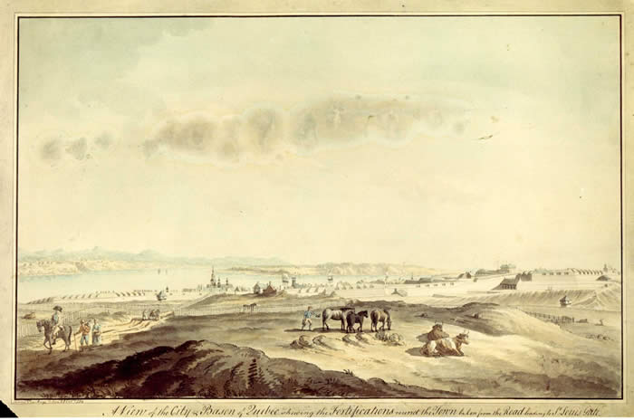
View of the Heights of Québec at the end of the eighteenth century.
Credit: J. Peachey, Vue des fortifications depuis les hauteurs, 1784, LAC.
The French Regime (1608–1759)
The first land concessions on the Quebec promontory, bisected by the Grande Allée, the road joining Quebec City and Cap-Rouge, date back to the 17th century, when the northern part was inhabited primarily by colonists belonging to the lower classes, and the southern part, which is today the Plains, by the elite class.
Among the first occupants of the Plains were the Sevestre family. Beginning in 1640, six of the eight concessions on the territory lying between what are today the ramparts and the Martello towers belonged to this family of printers and booksellers. Having fled Paris apparently to escape royal persecution on account of some of their publications, Charles, Thomas and Jacques Sevestre, accompanied by their mother, settled on the Plains. Charles was the only family member to have children; of his two sons and five daughters, only the latter carried on the family’s line of descent.
Once Charles died, a dispute arose among the heirs concerning the division of his property, in particular concerning a part of the Plains concession. Rather than divide the land, the parties agreed to draw lots; this resulted in Catherine Sevestre and her husband, Louis Rouer de Villeray, taking ownership.
Louis Rouer de Villeray was a member of a family of the lesser Italian nobility. He moved to New France around 1650, where he performed various administrative functions before becoming in 1663 the first counsellor in the Sovereign Council, making him the colony’s fourth-ranking official after the governor, the intendant and the bishop. Having inherited by marriage a number of parcels of land on the Plains, Rouer de Villeray expanded his holdings by way of various purchases and concessions, and by around 1660 he had a huge fief at the gates of the city on Quebec’s most attractive site. He called this estate “la Cardonnière.”
Louis Rouer d’Artigny, Rouer de Villeray’s second son, inherited the estate in 1701. He divided it up between 1720 in 1740, first because he had to, the colonial authorities having decided to erect a new line of fortifications, and second, possibly, to get some revenue. Louis Rouer d’Artigny died a bachelor in 1744. The Cardonnière estate was subsequently reassembled in the 1750s by herbalist Hubert-Joseph Lacroix.
In addition to the Sevestres and Rouer de Villerays, others occupied parcels of land on the Plains, beginning with, west of the Sevestres and, later, the Rouer de Villerays, the Augustines hospitalières of the Hôtel-Dieu. Between 1668 and 1702, they acquired four adjacent parcels of land on the site of what is now the Musée national des beaux-arts and the old prison. They did not use the land themselves, but leased it to various individuals who used it primarily for pasture. A century later, this land was still available for lease. However, its vocation had changed and it was now attracting members of the liberal professions who were building residences along the Grande Allée, as well as being used for recreation by the Army. Among the tenants were the daughter of the grand voyer [chief superintendent], an attorney, a law student, the manager of the Office des billets d’armée [bureau of army billeting] and Joseph Tardif, bailiff of the Quebec City courthouse.
Westward of the nuns’ estate, on what is now the Plains sports field, were families of colonists who in the 17th century lived on properties ranging in size from one to one and a half acres frontage, extending from the Grande Allée to the river. They included Marie Langlois, Zacharie Maheust a.k.a. Point-du-Jour, Jacques Maheust, Jean Côté, Jean Normand, Gervais Normand and his wife, Antoine Brassard, Père de Noël Pinguet, to name only a few. Most of them used the land for pasture, and very few for housing. The Ursulines began assembling land in 1668, and by 1737 they declared that they had land measuring 10 arpents frontage by 10 in depth. This acreage would give the Ursulines a measure of self-sufficiency should supplies become unavailable.
Strategic Value of the Heights of Abraham under the British Regime (1759-1860)
On September 18, 1759, just a few days after the decisive battle on the Plains of Abraham, Nicolas de Ramezay, the French Army lieutenant who had been responsible for defending the promontory, surrendered the city to the British. The military authorities immediately began evaluating its defensive system and soon saw the importance of occupying the Heights of Abraham. Upon arriving in Quebec, Governor Murray had a series of blockhouses built to ensure a military presence on this strategic site. Beginning in 1763, he began appropriating land for the construction of a citadel. The military was very concerned about the construction of civilian or religious buildings close to the fortifications. In the event of a conflict, the buildings must not be allowed to block artillery fire, to obstruct the view of the enemy or to provide refuge for them. This was precisely what happened in the siege of Quebec in 1775 and 1776, when the Americans used the buildings in the faubourg Saint-Jean to approach the ramparts.
The construction of defensive works, including a citadel, batteries, redoubts, etc., was seen by the military as a necessary part of occupying the Plains. The approach taken by engineer Gother Mann in 1791, for example, was to have two redoubts constructed on the Heights of Abraham 1750 metres away from the city enclosure in order to keep an enemy army from getting too close. At the same time, consideration was being given to the construction of a citadel.
The military encountered two major problems: on the one hand, the British government was reluctant to provide the funds required for the construction of the works requested, and on the other, pressure was being created by the city’s growth. The first problem was resolved in the early years of the 19th century when, faced with the imminent threat of a war with the Americans (the War of 1812), the military completed the ramparts, built powder magazines and strengthened the Saint-Louis Gate fortifications. Four Martello towers were also constructed on the Quebec promontory, two of which are on the current site of the Plains.
These new works did not obstruct the city’s growth. On the contrary, Quebec’s economic vitality attracted many immigrants, some of whom wished to live on the promontory. Moreover, the Ursulines and Augustines, major property holders, wished to divide their estates into lots in order to generate revenue out of their concessions. The faubourg Saint-Jean was well populated even before the construction of Martello towers 3 and 4 on the northern part of the promontory; in 1796 there were close to 1,000 residents, and by 1806, this number had doubled.
With this in mind, the military concentrated on acquiring land south of the promontory, including the Plains of Abraham as it now stands. Unlike the faubourg Saint-Jean, construction on the 1 and 2 Martello towers delayed the spread of civilian population in this sector. Nonetheless, the Heights of Abraham continued to be a coveted piece of real estate. Not for many years—around 1860—did the military control the Plains in its entirety. This was achieved by dint of property transactions (purchasing or rental) and, in some cases, constraint, with the property owners receiving compensation.
Having been left vacant for military reasons, the Plains now became a manoeuvring ground and a big playing field for garrisoned soldiers. It also attracted many visitors wishing to set foot on the site of the great battle. Thus in the course of the 19th century the Plains changed from a strategic site to one of history, assembly and recreation, all of which was enshrined by the creation of the Battlefields Park in 1908.
Jacques Mathieu and Alain Laberge, “À l’époque de la Nouvelle-France,” in Jacques Mathieu and Eugen Kedl dir., Les plaines d’Abraham: le culte de l’idéal, Sillery, Septentrion, 1993, pp.48-49.
In New France, an arpent measured about 60 metres.
Mathieu and Laberge, op. cit., p.48.
Yvon Desloges, “Du site stratégique à la ville fortifiée, 1759-1830,” in Jacques Mathieu et Eugen Kedl dir., Les plaines d’Abraham, p. 125.
Yvon Desloges, “Du site stratégique à la ville fortifiée, 1759-1830,” p. 126.
The Plains of Abraham, the Focus of Quebec City’s System of Defence
Quebec was officially recognized by UNESCO in 1985 as a world heritage city, a distinction owed in large part to the preservation of its fortifications. From the time of Quebec’s founding, the French placed emphasis on the defence of the new settlement. Although rather modest in the 17th century, the city’s defensive system was improved over time, making Quebec a real fortified city by the 19th century. In order for the system to be effective, it must be able to benefit from the natural advantages afforded by the local topography. Chief among these were the Quebec promontory, and especially its highest point, the Plains of Abraham.
The French fortifications
The first fortification works on the Quebec promontory date back to the late 17th century. The first enceinte, a wood palisade flanked by a few stone bastions, was built in 1690 to protect the city’s west flank. Three years later, with an impending British attack rumoured, Governor Frontenac and Intendant Champigny authorized the construction of a second enceinte: “This new and more regular line of defence encompassed a portion of the Cap-aux-Diamants heights and extended almost in a straight line to a point above the cliff overlooking la Potasse.” [translation] The original wood enceinte was replaced by a masonry wall; a redoubt was built on the shores of the Saint-Charles River, and another on the heights of Cap Diamant.
The works, supervised by le chevalier Boisberthelot de Beaucours, were found wanting by Jacques Levasseur de Neré, the colony’s new engineer, who landed in 1694. He felt that the fortifications should not have been constructed on this side of the heights of Cap Diamant. The engineer also felt that the redoubt on the heights was insufficient to keep an enemy from occupying this strategic location. Levasseur would therefore attempt to correct the errors in Beaucours’ works by constructing retrenchments atop the Cape and starting work on a new enceinte.
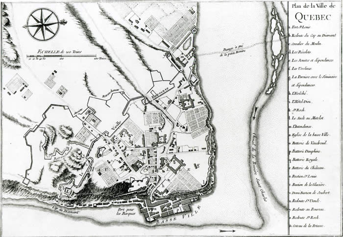
This plan of Québec shows the grip of institutions and fortifications
on the upper town.
Credit: Plan of Québec published in Charlevoix, Histoire et description générale de la Nouvelle-France, 1744, LAC.
1716 saw the arrival of a new king’s engineer, Gaspard-Joseph Chaussegros de Léry. He would hold the position until his death in 1756. During his career, he proposed a number of plans for Quebec’s fortifications, including, during his first years in the colony, the construction of a citadel on the heights of Cap Diamant. This proposal was shelved for lack of funds and unwillingness on the part of France. Under Maurepas, Secretary of State of the Marine from 1723 to 1749, the Conseil de la Marine strategy for the defence of the colony was focused no longer on the capital only, but on Louisburg and Montreal as well. France was now funding the fortification of these two cities, at Quebec City’s expense.
However, the situation changed in 1745, with the fall of the Fortress of Louisburg to the British. Panic stricken, Quebec City residents pressed the governor to improve its defences. An assembly made up of the governor, the intendant, the senior officers, the bishop and a few business representatives decided to build a new enceinte. Chaussegros de Léry drew up new plans incorporating the bastions constructed by Levasseur de Néré on the heights of Cap Diamant. He also proposed the construction of a citadel, but unsuccessfully. The decision to begin these works was taken without the knowledge of the metropolitan authorities, who had no choice other than to approve them and fund them in part. The remainder would be left up to the colonials.
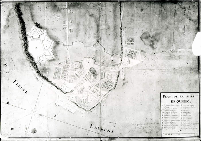
This map, designed by Chaussegros de Léry in 1722, depicts the engineer’s plans to fortify Quebec. One would note the Citadel located on Cap Diamant, citadel that was built only one century later. It was erected by the British.
Credit: Chaussegros de Léry, Plan de la ville de Québec, 1722, BAC.
Léry’s enceinte still had not been completed in 1759, on the eve of the siege of the city by General James Wolfe’s troops. A number of factors, including haste and insufficient planning, cost overruns, and changes of plans while the project was under way accounted for these delays. In any case, this fortification was not a critical factor in the defence of the city in 1759. On the contrary, once the British took the Heights of Abraham on the morning of September 13, the city became highly vulnerable, if not indefensible.
The British fortifications
Having moved into the city in the wake of Quebec City’s capitulation on September 18, 1759, the British conducted an inspection of the fortifications. This task was assigned to engineer Patrick Mackellar, who took note of the poor condition of Chaussegros de Léry’s enceinte, partly because it was not yet complete. In 1760, Governor James Murray ordered the completion of the ramparts and the construction of a series of seven blockhouses on the promontory. The governor also proposed the construction of a citadel, but, as in the case of his French predecessors, headquarters denied funding for the project.
The British understood very early the importance of occupying the Heights of Abraham. Confirmation of this came when the Americans decided to set up their camp and batteries there during the 1775–76 invasion of Canada. Although a failure, the American attack moved the colonial authorities to rethink the city’s defensive system. Frederick Haldimand, the governor of Canada from 1778 to 1786, had a topographic map of Cap Diamant prepared. Mindful of the costs involved, he hesitated between temporary wooden works and permanent masonry works. Although opposed by the engineers, the first option was chosen.
The work began in 1779 under the leadership of engineer William Twiss. Batteries, redoubts, retrenchments and bastions were constructed on the Quebec promontory. However, the most remarkable aspect of Twiss’s works was the construction of a sophisticated citadel, the temporary citadel, on the heights of the Cape, integrating the French works and in particular the bastions of the Ice House and the Cape.
Owing primarily to the lack of specialized labour and the rigours of winter, Twiss’s works proceeded very slowly and were even interrupted in 1783 by the signature of the Treaty of Versailles between England and the United States. While the treaty ended the hostilities, the respite was short-lived. The political situation in Europe and America revived tensions between the British and the French on the one hand, and the British and the Americans on the other. This led the colonial authorities to take a fresh look at the city’s defensive system. But one thing remained unchanged—the strategic importance of the Heights of Abraham.
Gother Mann, the engineer responsible for upgrading Quebec’s fortifications in the late 18th century, proposed the following four-point plan:
- build a rampart completely enclosing the Upper Town, not just its western flank;
- occupy the Heights of Abraham;
- protect Chaussegros de Léry’s enceinte using auxiliary defensive works;
- build a citadel.
Like his predecessors, Mann did not receive the funds needed to fulfill his ambitions. However, before leaving Canada in 1804, he did build a few powder magazines and the Prescott Gate on Côte de la Montagne, and repaired Léry’s enceinte. His plans were not forgotten; on the contrary, they were used during the first three decades of the 19th century to make Quebec a bona fide fortified city.
The threat of an American invasion was again instrumental in renewing the project to fortify Quebec in the early 1800s. Because of Napoleon’s continental blockade in Europe, London found it necessary to turn to Canada for its source of lumber and even ships. Thus the defence of the colony was crucial. It would take more than 25 years to complete Mann’s plans. The first step was raising the ramparts around the upper town, atop the cliff. Without waiting to hear from London, Governor Craig gave his consent to the construction of auxiliary works in the channel in front of the St. Louis Gate and to the erection of four Martello towers. Construction on the towers began in 1808 and was completed two years later, with the exception of the fourth tower, which was not completed until 1812. Finally, construction on the citadel began in 1820 and was completed in 1831, after which only the auxiliary buildings (the hospital, the prison, etc.) remained to be constructed.
From the founding of Quebec City to the middle of the 19th century, the Plains of Abraham was a site of strategic importance in the defence of the city. Overlooking the city and the river, the main avenue of communication, it was seen by the colonial authorities, both French and British, as the key to Quebec City’s defensive system, even though their plans for it were kept in check by cost and labour considerations.
From its modest beginnings under the French regime, the Heights of Abraham underwent considerable development under the British, who constructed the Murray Blockhouse, the temporary citadel, the Martello towers and the permanent citadel. Excavations were started in the summer of 2006 and have continued in 2007 for the purpose of restoring the remains of one of the seven blockhouses, situated on the Cap Diamant heights. The outline of the rampart for the temporary citadel is still visible on the Plains. Martello towers 1 and 2 are seated proudly on the heights and are used by the National Battlefields Commission for interpretation and period presentations. Finally, the citadel marks the eastern boundary of the Plains and is used for historical interpretation and, still, as a Canadian Forces base.
Blockhaus number 1.
Credit: T. Patten, 1761, Royal Ontario Museum.
A Martello tower is a permanent fortification work made of stone. The structure was used for centuries in the Mediterranean to combat piracy and became very popular when in 1794 a tower situated on Corsica’s Cape Mortella held two Royal Navy ships in check for two days. Impressed with their effectiveness, the British decided to build them along their shore for protection against the French threat. By 1808, they had 73 of them.
The line of the wall of Québec and the advanced fortifications,
Martello towers 1 and 2.
Credit: Gother Mann, 1791, LAC
Martello towers were also used in North America to defend the colonies. In all, 17 were built in Canada in the 19th century in Halifax, Quebec City, Kingston and Saint John. In Quebec City, mindful of the American threat, without waiting for London’s permission, Governor Craig authorized the construction of four Martello towers on the Quebec promontory, two of them—towers 1 and 2—on the Plains of Abraham. Towers 1, 2 and 3 were started in 1808 and completed in 1810, with tower 4 coming two years later. Although operational in the War of 1812, they remained unproven because Quebec was not attacked during the conflict.
With their simple architecture, Martello towers are inexpensive to build and easy to defend. They are placed almost parallel to the enceinte over the entire width of the promontory and afford one another mutual protection. The Western wall of the tower, which faces the potential enemy, is quite thick whereas the thinner eastern wall could easily be destroyed by cannon fire from the city should the tower be taken by the enemy. The towers in the centre (2 and 3) and those at the two ends (1 and 4) were made to house garrisons of about 20 and 12 men respectively. They were supposed to contain enough supplies to last their occupants about a month without needing relief.
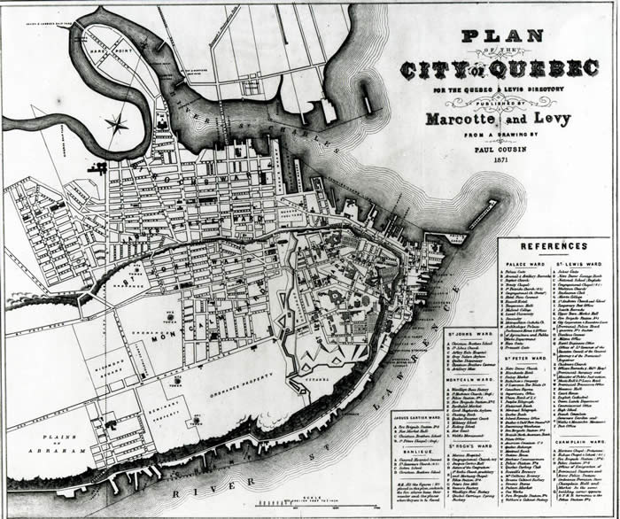
The permanent fortification works, especially the Martello Towers, appears on this 1871 Quebec city map.
Credit: Plan of the city of Quebec for the Quebec & Levis Directory, 1871, BAC.
Tour of a Martello tower
1. Entrance
The tower’s only access is on the upper storey and faces east, towards the enceinte. Once the ladder was drawn in, the enemy could not enter. A hook or block and tackle was sometimes placed above the outside door to bring in or put out heavy objects.
2. First floor: barracks
The original floors were made of wood, probably oak, and were left unpainted or painted grey. The stone walls were either left unpainted or were whitewashed with a mixture of lime, water and vinegar, which both made the room brighter and disinfected it. The barracks was the tower’s main room; in it the soldiers slept, ate and spent their free time. When entering, they would place their rifles on a wooden rack built around the central column. Lighting was provided by oil lamps hanging from the walls.
There were no latrines or washrooms in the towers, making personal hygiene problematic. The soldiers used chamber pots, the daily emptying of which was an unpleasant task.
The tower was also equipped with a fireplace used for heating, lighting and cooking. The accessories, supplied by the regiment, consisted almost exclusively of a large cooking pot hanging from the trammel and a serving ladle. A long table and two benches were used for meals and games. The soldiers provided their own settings consisting generally of a plate, a cup, a spoon and a knife.
Double bunk beds made of wood were arranged on the western wall. The very modest bedding, supplied by the regiment, consisted of a mattress, which was changed each year, and a grey woollen blanket.
Originally, the ground floor was usually accessed at the midway point between the central column and the fireplace. A wooden trap door was placed above a steep, space-saving stairway. Hanging from a large iron hook attached to the ceiling was a block and tackle used to lift heavy objects from the outside to the inside of the tower and bring them down to the lower floor, which was used primarily for storage.
Gun ports were also situated on the upper level of the barracks, one aimed northward and the other southward. Both were installed in embrasures. The space between the towers was protected by nine-calibre carronades.
3. Vault and walls
The arched roof adds solidity to the structure: joints shaken by a bombardment would tighten up and provide the stones with a better grip. The arched shape was obtained by building a wooden frame and placing upon it the stones (sandstone, limestone or brick) and mortar, a mixture of lime, sand and water. The wooden frame was removed when the mortar had set. The middle part of the central column, which supported the whole structure, was filled with stone and mortar debris.
The walls of the tower are also typical of this type of construction. The western wall, which would have borne the brunt of enemy fire, is quite thick and resistant. The wall facing the city is much thinner. In this way the tower could be destroyed from the enceinte if captured by the enemy. Holes in the Western Wall supplied air to the upper level. They form a baffle arrangement, joining one another in the back and extending inside the wall.
4. Accessing the platform
The stairway was designed so that the bulge in the axis around which it was built would protect the (normally right-handed) defender from an enemy but would leave the latter exposed if he should try to fire. Going up the stairway to the platform, one also sees the two firing-ports. These provide only a small opening from the outside but are wider on the inside, giving the shooter a wide angle for aiming and providing protection against enemy projectiles.
5. The platform
The main floor is separated from the roof supporting the platform by at least 1.8 metres* of brick. Although the platform was designed to hold five pieces of artillery, only three were actually installed.**
* Smaller sizes in towers 1 and 4
** The platforms for towers 1 and 4 were designed to hold three pieces of artillery, but only one was installed.
6. The ground floor
The western wall on this level was at its thickest, measuring about 5 metres (less in towers 1 and 4). As on the upper level, the floor was originally made of wood. The soldiers moved about carefully and wore shoes with soft soles or wooden pegs attached to avoid generating sparks.
The stores were located on the ground floor in a large room containing the rations. Garrisons were posted for a month and must bring everything they would need until relieved, including barrels of beef or salt pork, dried peas, flour, lamp oil, and so on.
Like the upper floor of the barracks, the ground floor had openings in the walls. Located at ground level, these evenly spaced holes provided air circulation throughout the tower. The weakness that would have resulted from these openings was offset by arches distributing the weight throughout the entire structure.
The preparation room, where charges of powder for various needs (charge bags and cartridges) were prepared, and the powder magazine were also located on this floor. Before working with gunpowder, the soldiers made sure that the doors were shut tight to keep any powder from leaking out and possibly catching fire. As its name suggests, the powder magazine was a place where powder was kept. It could hold up to 150 barrels (75 barrels in towers 1 and 4) of 75 pounds (34 kg) each. The many air holes in this room kept the powder dry. As in the main structure of the tower, the vaulted shape of the ceiling would protect the powder magazine should the upper floor cave in.
Finally, five tanks (three for towers 1 and 4) were situated in the ground under the tower to collect water, which flowed through gutters on the roof down through conduits in the stone structure. This water was used only in case of siege; Wells located nearby provided water for daily needs.
Chronology
| 1775-1776: | American War of Independence begins. The Americans attempt but fail to annex Quebec province. |
| 1808-1812: | Construction and arming of Quebec City’s four Martello towers. |
| 1809: | Work begins on building of a redoubt around Tower 2. It was never completed. |
| 1812: | Second American invasion of Canada stopped at Châteauguay, southwest of Montreal. |
| 1821: | Powder magazines are emptied and platforms disarmed |
| 1823: | Construction of cedar shingle roofs to protect towers and artillery from the weather. |
| 1846: | A watchman visits the towers regularly in the winter to maintain the lights and to air them when they are unoccupied. |
| 1850 (c.) | Tower 2 used as a surplus barrack for cavalry camping on the Plains. |
| 1857: | Roof and parapet of Tower 4 destroyed by fire. |
| 1860: | Towers occupied during the summer by about 20 soldiers |
| 1862: | Roof of Tower 3 destroyed by fire. It and the roof of Tower 4 would be rebuilt and covered with tin. |
| 1863: | Married artillerymen and soldiers barracked permanently in the towers despite poor living conditions. |
| 1864-1867: | Tower 1 used temporarily by an artillery laboratory following an explosion on the latter’s premises. |
| 1871: | British troops leave for England and the towers are handed over to the Canadian government. |
| 1892-1907: | A peace officer and his family live in Tower 4. |
| 1902-1936: | Roof of Tower 1 used to support the Ross Rifle Factory’s water tank. |
| 1905: | Tower 3 demolished to make room for the Jeffrey Hale Hospital’s Mackenzie building. |
| 1910: | Tower 4 acquired by the National Battlefields Commission, major renovation undertaken. |
| 1914-1918: | Tower 2 used for ammunition storage. |
| 1936: | Towers 1 and 2 acquired by the National Battlefields Commission, Tower 1 restored. |
| 1937: | Towers 2 and 4 restored. |
| 1941-1962: | Tower 1 used as an observatory by the Royal Astronomy Society of Canada. |
| 1964: | Tower 4 restored. |
| 1979: | Martello towers interpretation program established./td> |
| 1985: | Temporary exhibitions established. |
| 1992: | Restoration of towers 1, 2 and 4 and archaeological digs at Tower 2. |
| 1994: | Exhibitions set up at towers 1 and 2. |
| 2000: | Tower 2 prepared for public historical activities. |
The temporary citadel is a defensive work built on the Plains of Abraham, or, more specifically, on the heights of Cap Diamant. Work began in 1779 under the supervision of engineer William Twiss and includes the Cape and Ice House bastions erected under the French regime and the Murray Blockhouse built about 20 years earlier on the cliff’s edge. The work proceeded slowly due to a lack of specialized manpower and was interrupted in 1783 after the signature of the Treaty of Versailles ending the hostilities between the British and the Americans. The Citadel remained uncompleted. It was made of wood and earth—hence the “temporary” label—and was destroyed to make way for the construction of the current citadel in 1820.
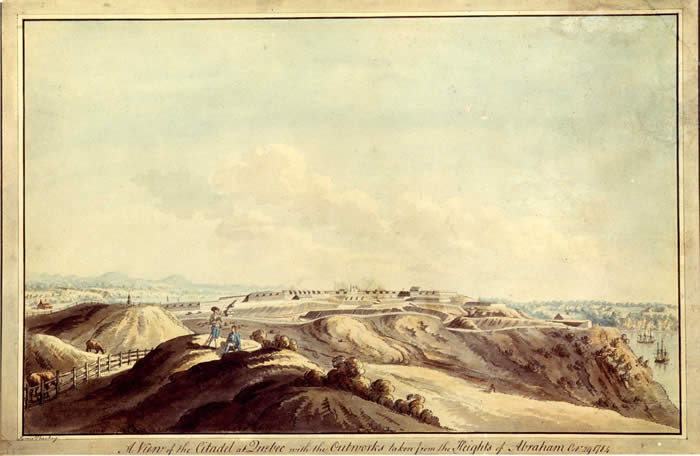 A View of the Citadel at Quebec.
Credit: J. Peachey, 1784, LAC.
Jacques Mathieu and Alain Laberge, “À l’époque de la Nouvelle-France,” in Jacques Mathieu and Eugen Kedl dir., Les plaines d’Abraham: le culte de l’idéal, Sillery, Septentrion, 1993, p. 70.
André Charbonneau, Yvon Desloges and Marc Lafrance, Quebec, ville fortifiée du XVIIe au XIXe siècle, Quebec, Éditions du Pélican, Parks Canada, 1982, p.35.
Jacques Mathieu and Alain Laberge, op. cit., p. 70.
André Charbonneau, Yvon Desloges and Marc Lafrance Québec, ville fortifiée du XVIIe au XIXe siècle, p.53.
Yvon Desloges, “Du site stratégique à la ville fortifiée, 1759-1830,” in Jacques Mathieu et Eugen Kedl dir., Les plaines d ‘Abraham, p.116.
Yvon Desloges, “Du site stratégique à la ville fortifiée, 1759-1830,” p. 121..
Ivan J. Saunders, A history of Martello Towers in the Defence of British North America, 1796-1871, Ottawa, National Historic Parks and Sites Branch, Parks Canada, Indian and Northern Affairs, 1976, pp. 31-32.
Yvon Desloges, “Du site stratégique à la ville fortifiée, 1759-1830,” p. 128.
Geoff Hutchinson, Martello Towers. A Brief History. Printed by M & W Morgan, Red Lake Terrace, Ore, Hastings, 1994. p.13.